
The key atmospheric variables are supporting El Nino build-up. Larger positive SST anomalies in the eastern Pacific Ocean have slowly but steadily expanded westward. El Nino, as such has amplified during the last couple of weeks and is expected to gradually strengthen further towards the fall of the year, through the monsoon season.
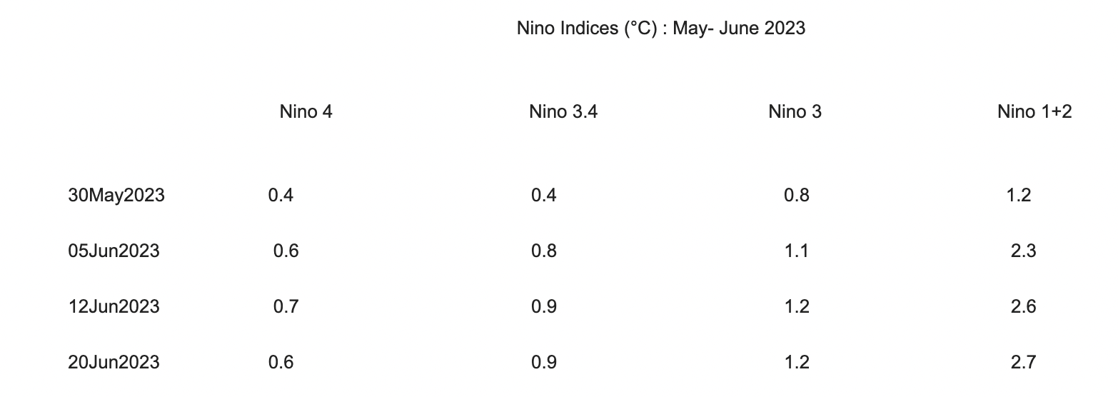
ENSO: The SST anomaly for Nino 3.4 during the Mar-May 2023 season was +0.22°C and for May 2023, it was +0.47°C. The most recent weekly (20 June 2023) anomaly in the Nino 3.4 region was 0.9°C. By definition, CPC requires that the monthly SST anomaly in the Nino 3.4 region ( 5°S-5°N: 170°W- 120°W) exceeds 0.5°C.
The Southern Oscillation Index (SOI) is also in the El Nino range. The last observed value as on 13 June 2023 was -13.9. The SOI is a standardized index based on the observed sea level pressure (SLP) difference between Tahiti and Darwin, Australia. The SOI is one measure of large-scale fluctuation in air pressure occurring between the western and eastern tropical Pacific. The negative phase of SOI represents below-normal air pressure at Tahiti and above-normal air pressure at Darwin. Prolonged periods of negative SOI values coincide with abnormally warm ocean waters across the eastern tropical Pacific, typical of the El Nino episode.
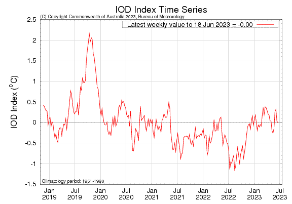
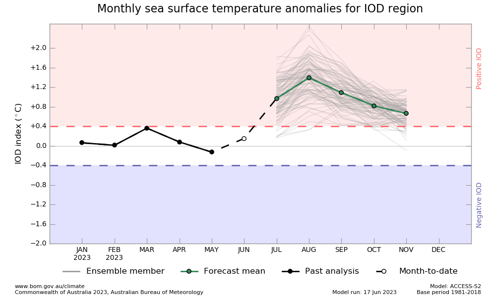
IOD: Indian Ocean Dipole is currently neutral. The IOD index for the week ending 18 June 2023 was 0.0°C, which is within neutral bounds ( between -0.4°C and +0.4°C). The index has constantly been dropping and reached the four-week lowest. As per the model survey, a positive IOD event may develop in the coming months. Model output, as of now, is not commensurate with the prevailing conditions. Presumably, there could be a lag of a few weeks and the index may turn adequately positive to negate the ill effects of El Nino. As per the Bureau of Meteorology (BOM), long-range forecasts of the IOD beyond August should be viewed with caution. Any strong IOD during the core monsoon months can dilute the drying effects of El Nino.
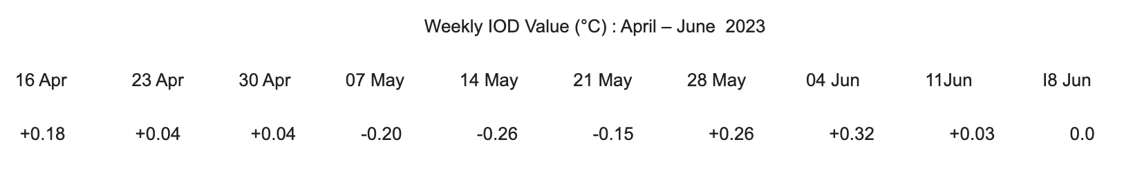
The IOD pattern so far is very erratic. It remains inconclusive to draw any relevant inference. It is expected to stabilize in the coming weeks.
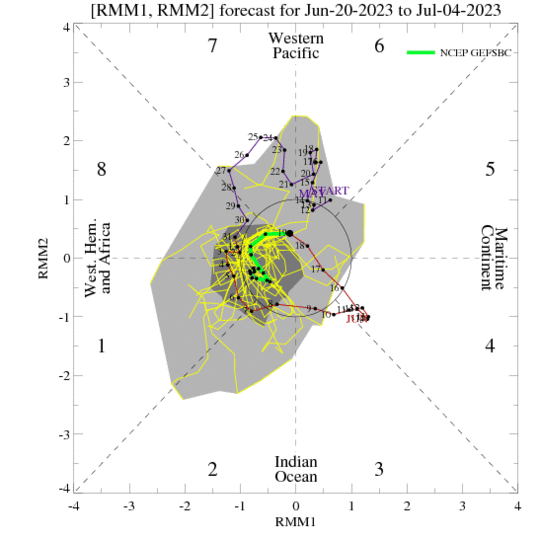
MJO: The ensemble forecast depicts the weakening of Madden Julian Oscillation signal back into the unit circle. Over the next 2 weeks, MJO will propagate across the Western Pacific and further on to Western Hemisphere. It supports a fair amount of chance of tropical cyclone formation in the Philippines Sea. The low amplitude of the MJO and its distant location over the Western Hemisphere may not influence any strong activity in the Indian Seas during the last week of June and the beginning of July.
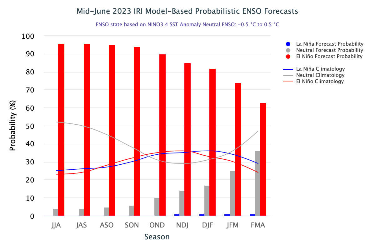
Based on the latest ENSO plume, the forecast indicates a high likelihood of El Nino conditions persisting during the monsoon months and extending to the fall of the year. The second most probable category throughout the forecast period is ENSO-neutral but with the probability of only 5-6% through the monsoon months.
