Updated on June 13, 2019 4:19 PM: Cyclone Vayu starts skirting Saurashtra coast, heavy rains begin in Diu, Junagarh, Porbandar, Dwarka
TheVery Severe Cyclone Vayuhas moved further closer to the coast and has started skirting the Saurashtra coast of Gujarat. With this, heavy rains have started lashing coastal parts the state. Places such as Amreli, Gir Somnath, Diu, Junagarh, Porbandar, Rajkot, Jamnagar, and Dwarka would see torrential during the next few hours.
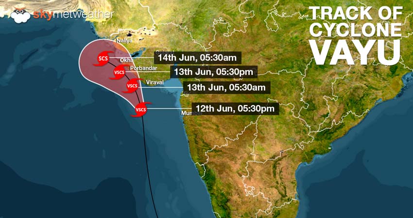
Thecyclonic stormis presently centered at Latitude 20.7°N and Longitude 69.1°E, about 100 km south of Porbandar, 190 km south-southwest of Diu, and 110 km southwest of Veraval.
These showers are accompanied with squally winds with the speed reaching up to 100 to 120 kmph, particularly over Gir Somnath, Diu, Junagarh, Porbandar and Dwarka. As the system moves further northwest, rains would cover more parts.
Skymet Weather has already predicted that rains widespread rains are likely over Gujarat with heavy to very heavy rains in wake ofVayu. As the Vayu moves further in Northeast Arabian Sea, it would encounter anti-cyclone, which would not let theCyclone Vayumove further. Slowly and gradually, the system would weaken and dissipate over the sea only.
Updated on June 12, 2019 11:59 PM: Very Severe Cyclone Vayu may not hit Gujarat, might just skirt the coast near Porbandar
In a new twist in the journey ofCyclone Vayu, there are fair chances that this very severe cyclonic may drift away from the Saurashtra coast. According to Skymet Weather, Vayu is tracking north-northwestwards. Weather models are now indicating that there is fair amount of probability thatvery severe cyclone Vayumay just skirt the Gujarat coast near Porbandar, close to Dwarka or Okha coast.
The system would continue to travel in water but proximity of coast might led to its weakening.Very severe cyclone Vayuwhich at present is Category 2 storm may weaken into a Category 1 storm. However, system would be packed with the winds to the tune of 135 kmph to 145 kmph gusting up to 175 kmph may cause damage.
As per weatherman, the reason behind the change in the track is that Vayu would encounter with weak steering environment.
As the system curves north-northwest, the speed of the system would become slow as . After crossing the Gujarat coast , Vayu would encounter an anti-cyclone over North Arabian Sea. As a result, the system might become stagnant near Karachi Coast. There are chances that Vayu may not make landfall and weaken in the sea itself. However, we need to wait and watch for all these probabilities.
At present, cyclone Vayu is centered at Latitude 19°N and Longitude 69.9°E, around 260 west of Mumbai and 320 km south of Porbandar. The system continue to move at a fast pace with the speed of around 15 kmph.
The periphery of the system is already reaching Gujarat coast. As a result, light rains with strong winds have begun over Saurashtra coast. We expect rain and thundershowers to intensify through night.
For the next two days, heavy to very heavy rains are likely right from Veraval to Okha. Places such Dwarka, Junagarh, Naliya and Rajkot would see heavy rains along with high velocity winds.
Image Credit:en.wikipedia.org
Any information taken from here should be credited to skymetweather.com