Updated on June 18, 04:10 PM:Cyclone Vayu dissipates, remnants to continue giving light rain in Gujarat for next 24 hrs
Cyclone Vayu in the Arabian Sea finally fizzled out on Tuesday over Saurashtra region of Gujarat. However, remnants of the system are seen as a cyclonic circulation over Saurashtra region.
The system would continue to give light rains with few moderate spells for the next 24 hours over most parts of the state, including interior parts as well. Coastal areas would also experience squally winds to the tune of 50-60 kmph.
Many places like Diu, Ahmedabad, Amreli, Anand, Aravali, Banas Kantha, Bharuch, Bhavnagar, Botad, Devbhumi Dwarka, Dohad, Gandhinagar, Gir Somnath, Jamnagar, Junagadh, Kachchh, Kheda, Mahesana, Mahisagar, Marvi, Panch Mahals, Patan, Porbandar, Rajkot, Sabar Kantha, Surendranagar and Vadodara would see rains on Tuesday.
Light rains could also be seen over Gujarat on Wednesday as well, but with reduced intensity.
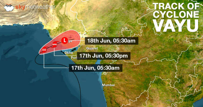
Updated on June 17, 15:50 PM:Cyclone Vayu to weaken further, to affect North Gujarat
TheCyclonic StormVayu over Arabian Sea continues to lose strength. Last nightCyclone Vayuweakened into a Deep Depression and is now seen as a Depression over Northeast Arabian Sea and adjoining areas.
The system is fastly moving in east-northeast direction, towards the North Gujarat coast and is now likely to weaken into a Well-Marked Low-Pressure Area by late evening.
It might make a landfall over Kutch region of Gujarat coast by midnight of June 17.
As the system makes a landfall, moderate rains and thundershowers are likely at many places with heavy rains at one or two places of the Saurashtra and Kutch region on June 17 and 18.
Cyclone Vayuhas also been giving light to moderate rains over the coastal areas of Maharashtra including Mumbai. Good rain and thundershower activities are expected over the coastal stations of Maharashtra today and tomorrow.
Places like Gondia, Dahanu, Mahabaleshwar, Ratnagiri, Alibag, Santa Cruz and Colaba would record rain and thundershower activities for the next 24 to 48 hours.
Updated on June 16, 08:15 PM:Cyclone Vayu to finally hit Gujarat on June 17 but as a depression
Moving in unfavourable weather conditions, the SevereCyclonic Storm Vayuover Northeast and adjoining northwest and Central Arabian Sea is now losing strength. Vayu would be weakening into a cyclonic storm by tonight and thereafter into a deep depression by Monday morning.
The system is presently centred at latitude 20.9°N and longitude 65.1°E, around 460 km west-southwest of Porbandar, 420 km west-southwest of Dwarka and 530 km west-southwest of Bhuj.
At present, the system is moving west-northwestwards but would re-curve towards the northeast direction and weaken further. Vayu would be crossing north Gujarat coast as a depression by midnight of June 17. With this, widespread rains are likely over many parts Saurashtra and Kutch and South Rajasthan on June 17 and 18.
Sea conditions would be rough to very rough along and off Gujarat coast till June 17.
Updated on June 15, 12:30 PM:Cyclone Vayu to give good rains along the coast of Southwest Gujarat June 17 onwards
There is a possibility of very severeCyclone Vayu weakening rapidly in next 48 hoursas it may recurve as a depression or a well-marked low over the Northeast Arabian Sea.
Northeast Arabian Sea will continue to witness very strong winds with a speed of 100-110 Kmph gusting at 135 Kmph, While coastal Gujarat will experience 50-60 kmph winds gusting at 80 Kmph, which will gradually weaken.
In the process, the cyclone will gradually move towards Coastal Gujarat and by June 17. Cyclone Vayu will give some good amounts of rain along the coast of Southwest Gujarat like Porbandar, Dwarka Okha and Jamnagar.
Updated on June 14, 05:00 PM:Veraval recordes 67 mm of rains in just a span of six hours, Cyclone Vayu continue to give heavy rains over Gujarat
Cyclone Vayu while skirting Gujarat coast has induced heavy rains over multiple coastal districts of Gujarat today. In managed to give heavy showers in just six hours while skirting through Saurashtra coast.
In a span of merely six hours from 8:30 am to 2:30 pm today,Veraval saw a whopping 67 mm of rains. Strong winds along with rough sea conditions marked the coastal city. At the same time, light rains were seen in Porbandar to the tune of 4 mm with Bhavnagar recording 4 mm rain as well.
These rains are expected to continue for a few more days as the Cyclone hangs around in the Arabian Sea for a while before it undergoes weakening.
The rain intensity is expected to increase on June 17 and 18, as Vayu will recurve northwestwards after 48 hours, reaching Kutch on June 18 as a Depression.
Updated on June 14, 11:30 AM:Effect of Cyclone Vayu not over yet over Gujarat
In the last 24 hours,Cyclone Vayuhas led to moderate rains over the coastal regions of Diu, Junagarh and Dwarka. Squally winds to the tune of 70-80 kmph were reported at multiple places like that of Porbandar, Dwarka, Junagarh and Diu.
Cyclone Vayuis now moving in West-Northwest Direction away from Gujarat. So, the intensity of rains will reduce by tomorrow.
We expect revival of rains over many parts of Gujarat as we expect the Cyclone to recurve in Northwest direction after June 16 while weakening gradually. The system will reach Kutch region on June 18 as a Depression or a Well-Marked Low.
Updated on June 13, 05:00 PM:Cyclone Vayu begins brushing Gujarat coast, heavy rains lash Diu, Junagarh, Porbandar, Dwarka
TheVery Severe Cyclone Vayuhas now further moved close to the coast while skirting the Saurashtra region of Gujarat. Heavy rains have now begun over the coastal areas. A few areas like Junagarh, Porbandar, Somnath, Diu, Rajkot, Jamnagar, and Dwarka are gearing up for torrential during the next few hours, gradually spreading over other parts. These rains will be accompanied with strong winds to the tune of 100 to 120 kmph. As the Vayu moves further in Northwest direction, it would be encountered by an anti-cyclone, which would not let theCyclone Vayumove further. Hence, the system would weaken and dissipate over the sea only.
Updated on June 13, 11:55 AM:Cyclone Vayu to escape Gujarat coast, but to give heavy rains in Jamnagar, Junagarh, Porbandar
As predicted by Skymet Weather, the very severe cyclone Vayu is now only going to skirt the Saurashtra coast of Gujarat. But as Vayu still continues to the sustained strength of category 2 typhoon, It would still give heavy to very heavy rains over Gujarat.
Gujarat continues to be on red alert, with Cyclone Vayu centred at Latitude 20.3°N and Longitude 69.5°E over the northeast and adjoining east-central Arabian Sea. It is about 130 km south-southwest of Diu, 90 km southwest of Veraval and 130 km nearly south of Porbandar.
Heavy to very heavy rains along with damage potential winds are likely over Amreli, Gir Somnath, Diu, Junagarh, Porbandar, Rajkot, Jamnagar, and Dwarka. Some places would see extremely heavy rains also. This might lead to inundation in low lying areas. Other parts of Gujarat region such as Ahmedabad, Gandhinagar and Surendernagar would see good rains with few isolated heavy showers of rain.
Updated on June 13, 7:15 AM:Very Severe Cyclone Vayu may not hit Gujarat, might just skirt the coast near Porbandar
In a new twist in the journey ofCyclone Vayu, there are fair chances that this very severe cyclonic may drift away from the Saurashtra coast. According to Skymet Weather, Vayu is tracking north-northwestwards. Weather models are now indicating that there is a fair amount of probability that very severe cyclone Vayu may just skirt the Gujarat coast near Porbandar, close to Dwarka or Okha coast.
The system would continue to travel in water but the proximity of coast might lead to its weakening. Very severe cyclone Vayu which at present is Category 2 storm may weaken into a Category 1 storm. However, the system would be packed with the winds to the tune of 135 kmph to 145 kmph gusting up to 175 kmph may cause damage.
As per weatherman, the reason behind the change in the track is that Vayu would encounter with weak steering environment.
Updated on June 12, 8:00 PM:Very Severe Cyclone Vayu gets closer to Gujarat, rains to begin in Saurashtra any time now
Vayu continues to retain the strength of a very severe cyclonic storm during the last 12 hours. The storm has been tracking north-northwest direction and is presently centred at Latitude 19°N and Longitude 69.9°E, around 280 km west of Mumbai and 340 south of Porbandar.
According to Skymet Weather, as of now, Cyclone Vayu is moving at a fast pace of around 15 kmph. With this, clouding have already reached Saurashtra region of Guajarat. Several places have alos started encountering squally winds. We expect rains to begin anytime now. Initially, rains would be light but would eventually pick up the pace by midnight.
Updated on June 12, 5:00 PM:Gujarat gears up for Very Severe Cyclone Vayu
Gujarat is gearing up for heavy to extremely heavy rains as Very Severe Cyclonic storm Vayu is nearing the coast. The system is presently centred at Latitude 18°N and Longitude 70.3°E, 230 km west - southwest of Mumbai and 290 km nearly south of Veraval.
Cyclone Vayu is the first cyclone to hit the Gujarat coast in the last one decade.
The system is moving at a fast pace, with a speed of 11 kmph in the northward direction. The system is most likely to make landfall over Saurashtra coast of Gujarat around west of Veraval as a Very Severe Cyclonic Storm by late tonight or wee hours of June 13.
Updated on June 12, 4:00 PM:Very Severe Cyclone Vayu gets more closer to Mumbai and Gujarat Coast
Retaining its strength, the Very Severe Cyclonic Storm Vayu moves further close to Mumbai and Gujarat coast. It is now centered at Latitude 18°N and Longitude 70.3°E, 230 km west¬southwest of Mumbai and 290 km nearly south of Veraval. It is very likely to move northwards andhit Saurashtra coast of Gujarat around west of Veraval as a Very Severe Cyclonic Stormby late tonight or wee hours of June 13. It would be accompanied damaging winds to the tune of 145-155 kmph gusting up to 170 kmph.
Updated on June 12, 1:30 PM:Rains and thundershowers over Madhya Pradesh in wake of Cyclone Vayu, heat wave abates
Rains are going on overmultiple districts of Madhya Pradeshfor the last 24 hours in the wake of Cyclone Vayu. Now, we expect these rains to continue over the state for the next two to three days.
Scattered rain and thundershower activities along with isolated dust storm are likely in many parts of the state, particularly in Bhopal, Ujjain, Ratlam, Indore, Hoshangabad, Betul, Jabalpur, Mandla, Dewas and Seoni during next the 48 hours.
These rains have led to a drop of temperatures over the region already. In the wake of these activities, severe heat wave conditions would abate many parts of the state.
Updated on June 12, 12:30 PM: Rains and windy conditions ahead for Mumbai as Cyclone Vayu passes close by
As the Very Severe Cyclone Vayu moves west of Mumbai, maintaining a distance of 260 km from the coast,Mumbai is yet again gearing up for rainsin the later parts of the day today. Rain intensity is set to increase, due to the movement of the storm. Cyclone Vayu will bring in winds gusting up to 60 kmph over the city.
Thus, windy afternoon with some rains may be seen over the city of Mumbai. Moreover, the waves will also be high, reaching the height of about 8 to 10 feet.
Updated on June 12, 8:30 AM: Red Alert issued for Cyclone Vayu, 3 lakh people to be evacuated
A red alert has been issued forCyclone Vayu which is likely to hit Gujarat coaston June 13.
Government rescue agencies will beevacuating over three lakh peoplefrom Gujarat and Diu in light of the Very Severe Cyclone Vayu.
Damage is expected in the coastal areas of Gujarat such as Kutch, Devbhoomi Dwarka, Porbandar, Rajkot, Junagarh, Diu, Gir Somnath, Amreli and Bhavnagar.
Around 39 NDRF teams are being deployed in Gujarat and Diu while 34 Army teams have been put on standby. Also, aerial surveillance is being carried out by IAF.
Updated on June 12, 7:00 AM:Vayu becomes Very Severe Cyclonic Storm
Vayu, which had become aSevere Cyclone last night, intensified further into aVery Severe Cyclonic Stormduring the wee hours of Wednesday. The storm is currently in the East Central Arabian Sea near Latitude 17.1°N and Longitude 70.6°E and is 420 km WNW of Goa, 320 km SSW of Mumbai.
In the last six hours, the storm has had a fairly fast movement at the speed of 18 kmph. Vayu is expected to cross Saurashtra Coast in Gujarat around Veraval.
Updated on June 11, 10:00 PM:Cyclone Vayu intensifies into Severe Cyclonic Storm
Cyclonic Storm Vayuhas now intensified into aSevere Cyclonic Stormand is near Latitude 16.1°N and longitude 70.6°E. The storm is over Eastcentral Arabian Sea, 350 km WNW of Goa, 410 km SSW of Mumbai . Vayu is likely to cross Gujarat coast between Porbandar and Mahuva during the wee hours of June 13.
Thus, heavy to very heavy rains are expected over many parts of Gujarat Coast. Sea conditions will remain rough and rains will be accompanied with very strong winds
Updated on June 11, 8:20 PM:Ministry of Home Affairs issues alert for Gujarat and Diu
Following the High-Level Review meeting taken by Union Home Minister on Cyclone Vayu, Ministry of Home Affairs has issued detailed advisories to the State of Gujarat and UT of Diu requesting them to take all precautionary measures with a view to ensure that no human life is lost, damage to vital infrastructure is minimized and to ensure early recovery of all essential services post-cyclone landfall. State/UT Governments have also been advised for timely evacuation of people from low-lying coastal and vulnerable areas.
Gujarat and Diu Administration have planned to evacuate about 3 lakh people from the identified vulnerable areas starting the early morning of 12th June, 2019. The evacuated people will be shifted to around 700 cyclone/relief shelters. In consultation with State Administration, 39 NDRF Teams are being pre-positioned in and Diu for helping the State/UT Administration in evacuation, search, rescue and relief operations. In addition, 34 teams of Army are also put on stand-by.
Union Home Minister is regularly reviewing the situation and Union Home Secretary will take a review meeting on 12th June with the Central Ministries/Agencies and Chief Secretary/Adviser of Gujarat and Diu.
Updated on June 11, 4:30 PM:As Cyclone Vayu inches North-Northwestwards, rains begin in Mumbai
Mumbai rains have already begun over some suburbs later today. Afew areas are also reporting lightningand thundershowers. These rains are being brought about by Cyclone Vayu which at present is located close to Mumbai coast, while it is moving further in North-Northwestwards direction.
Rainfall in Mumbai is expected to continue today with the intensity of showers increasing further tomorrow.
Updated on June 11, 9:30 AM:Cyclone Vayu to soon become a Severe Cyclone, heading towards Gujarat coast
As Cyclone Vayu keeps tracking northwards, parallel to the West Coast, it would continueto intensify rapidly and would strengthen into a Severe Cyclonic Stormduring the next 24 hours.
Cyclone Vayu is likely to strike Saurashtra coast of Gujarat, between Porbandar and Mahuva around Veraval and Diu region as a Severe Cyclonic Storm by the late night of June 12 or early morning of June13.
TheCyclone would give heavy to extremely heavy rainsover areas such as Porbandar, Veraval, Jamnagar, Dwarka, Junagarh and Okha. At the time of crossing the coast, these areas would see damaging winds with the speed of 110-120 kmph gusting to 135 kmph.
Mumbai would escape the fury of Cyclone Vayu, however, sea conditions are likely to be rough to very rough along the Maharashtra coast on June 12.
Updated on June 11, 7:30 AM:Cyclone Vayu forms in the Arabian Sea, heading towards Saurashtra
The deep depression which was over east central and adjoining Southeast Arabian Sea has finally intensified into Cyclonic Storm Vayu. The system followed a north northwestward direction at 12 kmph and was near Latitude 13.9°N and Longitude 70.6°E. Vayu was 380 km NW of Aminidivi 630 km SSW of Mumbai and 780 km S of Veraval.
The system will concentrate into a Severe Cyclonic Storm by tonight and move northward, further becoming a Severe Cyclonic Storm. The system is heading towards Saurashtra Coast.
Updated on Jun 10, 8:30 pm:Deep Depression To Intensify Into Cyclone Vayu
TheDeep Depression will now intensify into a Cyclonein the east-central Arabian Sea, which would be named as Vayu. It would continue to move in North-northwest direction towards Gujarat. Thus, light to moderate rains with few heavy spells will be seen in parts of Kerala. While moderate to heavy rains would be seen in Coastal Karnataka.
Fewer rains are expected in the interior parts of the Peninsula. Amidst this, light rain with one or two moderate spells are likely over South Interior Karnataka including Bengaluru and North Coastal Andhra Pradesh. While, isolated rains will be seen over Rayalaseema, Telangana and Tamil Nadu.
Updated on Jun 10, 3:50 pm:Depression To Intensify Into Cyclone Vayu By June 11
At present, the Depression is moving in the favorable weather conditions of warm sea surface temperatures and low vertical wind shear. If the situation remains the same, it’s likely thatCyclone Vayuwould strengthen into Deep Depression by the evening of June 10. Subsequently, it might turn into into aCyclonic Storm by June 11. By this time, the likelyCyclone Vayuwould be near Konkan & Goa coast, close to Mumbai with a distance of 300 km.