Updated on June 13, 2019 8:15 AM: Vayu to not make landfall over Saurashtra, to just brush the coast
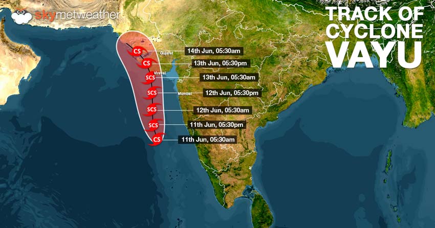
In a turn of events,Cyclone Vayu, which continues to be very severe cyclonemay not hit the Saurashtra coast. According to Skymet Weather, Vayu is tracking north-northwestwards. As per weather models , the very severe cyclone Vayu may skirt the Gujarat coast near Porbandar, close to Dwarka or Okha coast.
The weakening would take place due to its proximity of the coast as it is likely to become a Cat 1 storm. However, winds to the tune of 135 kmph to 145 kmph gusting up to 175 kmph may cause damage over the Gujarat coast.
As per Skymet Weather, cyclone Vayu may encounter weak steering environment, the system could change its track. As the system curves north-northwest, Vayu’s speed will also become slow. After it skirts the Gujarat coast , Vayu is also likely to encounter an anti-cyclone over North Arabian Sea which will result its stagnation near the Karachi Coast. There is also a likelihood of Vayu making no landfall and weakening in the sea itself.
Updated on June 12, 2019 8:30 AM:Vayu becomes a Very Severe Cyclone, heading to Saurashtra
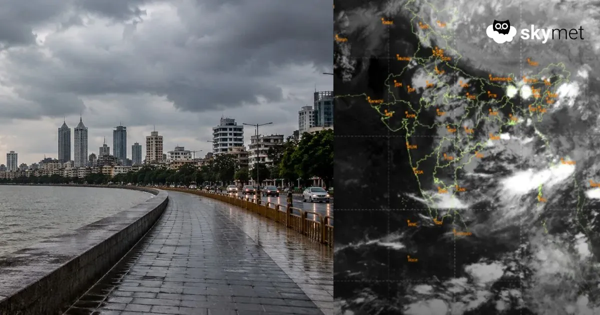
Severe Cyclone Vayu has become a Very Severe Cyclonic storm during the wee hours of Wednesday. The storm is in the East Central Arabian Sea near Latitude 17.1°N and Longitude 70.6°E and is 420 km WNW of Goa, 320 km SSW of Mumbai.
In the last six hours, the storm has moved fast at a speed of 18 kmph. Vayu is expected to cross Saurashtra Coast in Gujarat around Veraval.
Rain in Gujarat will also begin as the very severe Cyclone moves towards Gujarat. The storm will pack winds up to 130 kmph and will bring in heavy to very heavy rains over many parts of Gujarat.
Updated on June 11, 2019 10:00 PM: Cyclone Vayu become severe cyclone, to hit Gujarat coast soon
After sustaining strength of acyclonic stormfor a brief period, Vayu intensified into severe cyclonic storm in less than 24 hours. Vayu has also developed and eye, indicating towards a very powerful storm.
It is presently centered around Latitude 16.1°N and Longitude 70.6°E, about 380 km south-southwest of Mumbai and 500 km nearly south of Veraval. The system would continue to move at a rapid speed in north direction, sustaining its strength.
Vayu is likely to make landfall over Gujarat coast, near Veraval and Diu region around the late night of June 12 or wee hours of June 13 as severe cyclone. The system would batter Gujarat coast with torrential rains accompanied with high velocity winds to the tune of 110 kmph-120 kmph, gusting even up to 135 kmph. The system would have great damage potential.
On its way to Gujarat, Vayu would also give intense spells along the Maharashtra coast. Mumbai would also see some intense rains. Intense clouding can already be seen over the Konkan region.
Updated on June 11, 2019 10:10 AM: Cyclone Vayu forms in Arabian Sea, severe cyclone likely by June 11 evening
Cyclone Vayufinally made an appearance in Arabian Sea on Tuesday morning and is centered at Latitude 14.7°N and Longitude 70.6°E over East-central Arabian Sea, around 490 km south-southwest of Mumbai and 600 km nearly south of Veraval.
As predicted by Skymet Weather, the system has been travelling very favourable weather conditions and thus, rapidly intensifying. Moving at a fast pace,Vayuwould continue to become more powerful very soon and would strengthen into a Severe Cyclonic Stormby today evening i.e. by June 11.
Vayu would continue to track northwards, parallel to the West Coast with a distance of around 300 km. However, it would re-curve with the Indian terrain and thus likely to hit Saurashtra coast of Gujarat, between Porbandar and Mahuva around Veraval and Diu region as a Severe Cyclonic Storm by the late night of June 12 or early morning of June 13. It would be accompanied with high velocity with the speed of 110-120 kmph gusting to 135 kmph.
Heavy to extremely heavy rains are likely over Porbandar, Veraval, Jamnagar, Dwarka, Junagarh and Okha, which could possibly inundate low lying areas.
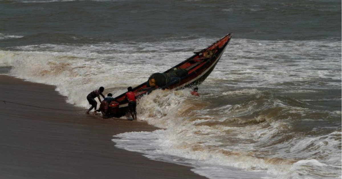
Till then, the system would continue to give intense rains and squally winds all along the coastal areas of Karnataka, Goa and Maharashtra. Sea conditions would be rough to very rough Fishermen are advised to exercise precaution and avoid venturing in deep waters during that time.
Cyclone Vayu would be abeam Mumbai today afternoon but would escape the fury of Cyclone Vayu.However, it would see good rains and high velocity winds. Sea conditions are also likely to be rough to very rough along the Maharashtra coast on June 12 as the Cyclone Vayu passes by.
Updated on June 10, 2019 8:10 PM: Deep depression to become Cyclone Vayu by June 11 morning, severe cyclone likely
The deep depression over east-central and adjoining southeast Arabian Sea is all set to intensify intoCyclone Vayuby the morning of June 11. The system is presently centered at latitude 12.5°N and 70.9°E, around 650 km south-southwest ofMumbaiand 850 km south-southeast of Veraval.
According to weathermen, the wind bands continue to get more organised. In fact, the likely tropical storm is travelling from favourable condition to more favourable weather conditions. With this,Vayuis likely to become Severe Cyclonic Storm during the subsequent 24 hours.
As the system moves north-northwest, the sea surface temperatures have further increased and are in the range of 30°C-31°C. Vertical wind shear is also low. All these factors have led to rapid intensification of the probable Cyclone Vayu in the last 24 hours. Further also, we do not seen any dip in the speed.
As per scientific definition, if the wind speed of any weather system increases by 55 kmph or more, it is said to be rapid intensification.
The speed of any weather system is measured on account of its wind speed and pressure. More the wind speed and lower the pressure is, faster would be the intensification of the system.
Normally if the weather system in travelling in deep Arabian Sea, it would have started deepening. However, this probable cyclone is travelling near the West Coast, maintaining a safe distance of 300 km.
The unique property of this system is that it is going spend a lot of time near Saurashtra coast of Gujarat. The likely cyclonic storm would be travelling in north-northwestwards for the next 48-72 hours, later on turning along the Indian coastline.
As per weathermen, thecyclone would be closest towards Saurashtra coast. While changing its course, the speed of the system slows down and that is how it would get to spend maximum time near the Saurashtra.
Thus,Gujarat coast needs to be on alert as likely Cyclone Vayuis expected to sweep the area in terms of rains and squally winds for amount of time.
Image Credit: Times Magazine
Any information taken from here should be credited to skymetweather.com