
Updated May 30:
At present, the well-marked low pressure area over Southeast Arabian Sea off Kerala and Karnataka Coast has become insignificant. Consequently, we expect the saga of moderate to heavy rain over Coastal Karnataka and parts of North Kerala to ease.
[yuzo_related]
Past 24 hours, the system has given extremely heavy rains along the coast of North Kerala as well as Karnataka. Mangaluru recorded hefty rainfall to the tune of 334 mm, followed by Cannur 124 mm, Madikeri 76 mm, Thrissur 55 mm, Kozhikode 44 mm, Gadag 38 mm, Agumbe 35 mm and Honavar 23 mm.
Nevertheless, light to moderate rain and thundershowers are expected to continue during the next 24 to 48 hours. As the weather system is most likely to weaken and fade away soon, so the intensity of the showers will also take a back seat. However, scattered showers will continue and the weather will start improving.
Updated May 29: Well marked low in Arabian Sea to fade, rain in North Kerala, Coastal Karnataka, Konkan & Goa
As per Skymet Weather experts, the well-marked low pressure area over Arabian Sea off Kerala and Karnataka Coast would give moderate to heavy rain and thundershowers over Konkan and Goa, Coastal Karnataka and parts of North Kerala during the next 24 to 48 hours.
Thereafter, this weather system is expected to weaken. Consequently, the rain intensity will decrease along the west coast of the country.
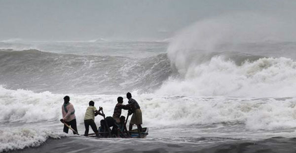
The sea conditions over Konkan and Goa, Coastal Karnataka and parts of North Kerala will remain rough. Also, the wind speed is likely to gush up to 30-40 km/hr. In fact, the wave heights along the coast would also extend up to 6-8 feet.
Hence, we highly advise the fishermen to avoid fishing and other off shore events for at least the next 48 hours and exercise caution if needed.
Updated May 28: Well Marked Low in Arabian Sea to give heavy pre Monsoon rain along West Coast
As per weather experts, the low pressure area over Southeast Arabian Sea off Kerala and Karnataka Coast has intensified into a well-marked low. With this, we can expect Kerala and Coastal Karnataka to receive heavy to very heavy rainfall and thundershowers during the next 48 hours.
Further, primarily the weather system is likely to move in northerly direction and subsequently it is expected to recurve towards the northwest away from the Indian Coast.
So as of now, the sea conditions are expected to be rough along the coastline of Kerala, Karnataka and Maharashtra during the next 48 hours. Moreover, the moderate to strong winds are also likely to blow the west coast of the country during the same time period.
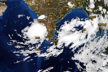
Following image shows the cloud cover and strengthening of the weather system
In consequence to this, we highly advised the fishermen to take precautionary measures while venturing around the stern sea for at least the next 48 hours.
As per Skymet Weather, gradually the rain intensity is expected to decrease by June 1. This would be in accordance to the weather system that is expected to move further away from the Indian Coast towards the central Arabian Sea.
Skymet Weather forestalls Monsoon to be knocking the door at Kerala. What is more, just steps away from Coastal Karnataka and Coastal Maharashtra.
Image Credit: youtube.com
Any information taken from here should be credited to skymetweather.com
