
 It has not been quite long when we had declared curtains down for La Niña in May. However, it seems that El Niño was in a bit hurry to make an appearance.
Weathermen were of the view that 2018 would be a devolving La Niña year during the Monsoon, followed by neutral ENSO (El Niño Southern Oscillation). However, weather conditions changed at a rapid pace and devolving La Niña was followed by evolving El Niño.
[yuzo_related]
There are several weather agencies across the world keeping a close watch on the development of oceanic parameters such as La Niña, El Niño, MJO (Madden-Julian Oscillation) and IOD (Indian Ocean Dipole). Undoubtedly, El Niño is the most talked about topic as it has a profound impact on the weather around the globe, particularly over the Indian Monsoon.
Last week, renowned agencies, NOAA and BOM have issued an El Niño watch after monitoring it for months. Early in the year, chances of El Niño evolving that too during Monsoon were bleak. Weather models were predicting El Niño by August or September, but the probability was as low as 20%-30% in March.
However, with continuous warming of the ocean waters in Pacific forced meteorologists to issue an El Niño watch as early in June. El Niño watch is issued when weather conditions are favourable for the development of El Niño in the next six months.
There are three stages: a) El Niño Watch, b) El Niño Advisory and c) Final El Niño Advisory. Hence, we have begun with the first stage of El Niño.
El Niño conditions are declared when the Oceanic Nino Index (ONI), which is three months running mean of SST (Sea Surface Temperatures) anomaly in the Nino 3.4 region, is more than or equal to 0.5°C for overlapping 3 months for five consecutive episodes.
According to Skymet Weather, the ocean indices in the Pacific area are currently neutral but they are showing promising signs of potential increase over the next few months.
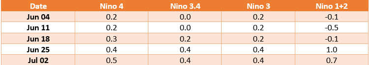 Currently, the western Pacific is warmer than the eastern one. It seems that warm water from the west is creeping eastwards. At present, SSTs are neutral, but they are showing a trend of gradual warming of the ocean waters. This trend has been noticed since last April.
Besides this, thermocline i.e. waters below the surface of ocean, is warmer than the average, which is a common and prominent precursor before the El Niño conditions appear.
The El Niño projections made in the last four months indicate significant increase in the chances for the arrival of El Niño towards the fall of the year.
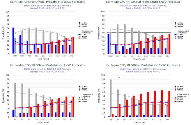 The above mentioned picture indicate that contrary to the projection in March, probabilities of El Niño in June have risen significantly to 50% by August and September.
However, there is no consensus built so far among the international climate models over the timings of arrival of notorious El Niño. Hence, we have to wait and watch till the time climate models reach consensus on the likelihood of El Niño conditions during the Monsoon months or thereafter.
In addition to this, the atmospheric conditions over the tropical pacific also need to exhibit some typical characteristics.
The mention of El Niño is itself enough to strain forecasters as evolving El Niño is as capable as El Niño for spoiling the Monsoon.
Image Credit:en.wikipedia.org
Any information taken from here should be credited to skymetweather.com
