

Cold anomalies in the Tropical Pacific are still sustaining the trade winds in the equatorial belt. This situation has supported the La Nina to endure through the spring season and rather extend far into 2022. El Nino / La Nina events tend to develop during the period April – June and reach their maximum strength during October – February. Typically, they persist for 9-12 months, though occasionally extend beyond 2 years. The current episode of La Nina had begun with monsoon 2020 and is continuing till now with a mild drop during July/August 2021. When in continuation, the 2nd year cooling as such is weaker than the 1st event. La Nina had earlier shown signs of shrinking during January/February 2022, casting speculations of its likely fading by end of the spring season of the Northern Hemisphere.
ENSO: The tropical Pacific atmosphere is consistent with La Nina. Equatorial Sea Surface Temperatures (SSTs) are below average across most of the Pacific Ocean. During the last 2 weeks, below-average SSTs have strengthened in the eastern equatorial Pacific Ocean. Extending it further, over the last 4 weeks, -ve SST anomalies have become stronger in the eastern Pacific and have not still lowered their guard in the central and east-central Pacific, as well. Even, the upper ocean heat content and thermocline slope convincingly support La Nina. However, there is no absolute clarity about the timings of change over from La Nina to ENSO neutral. Candidly speaking, there are equitable odds of La Nina and ENSO- neutral during the Northern Hemisphere Summers. It may further take a while to announce the final verdict.
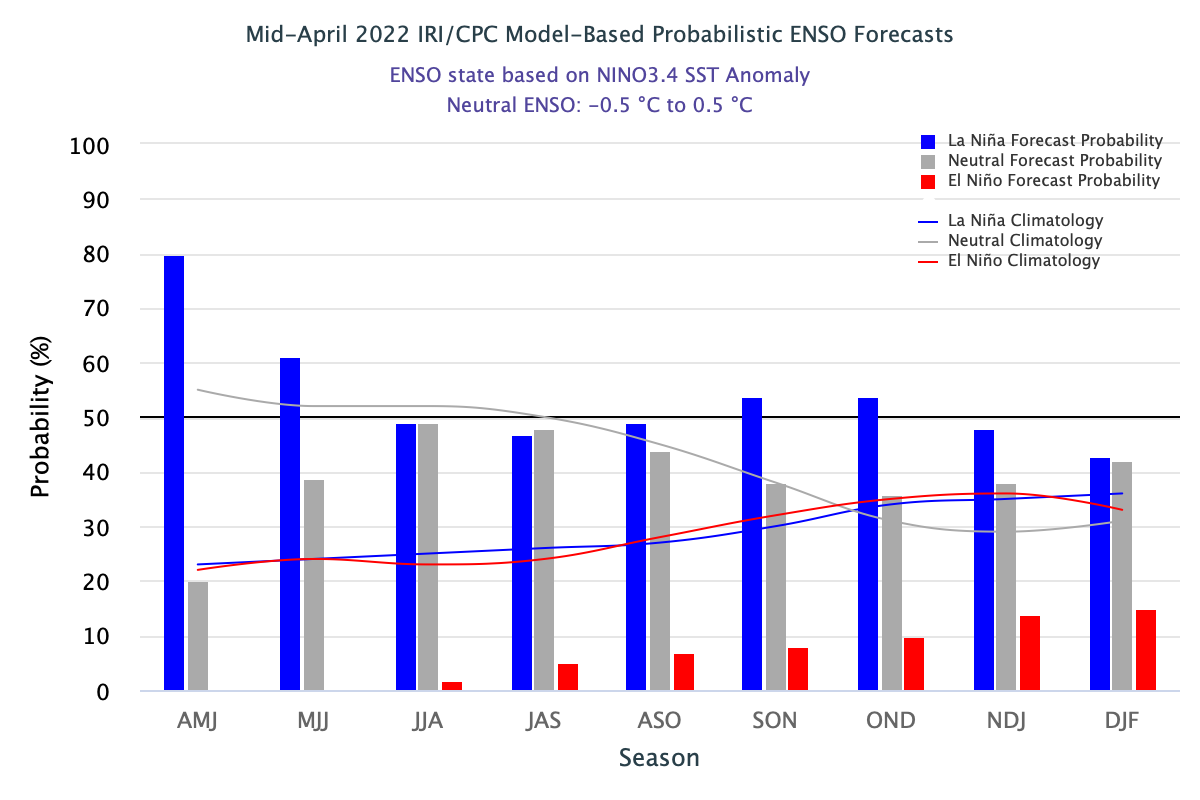
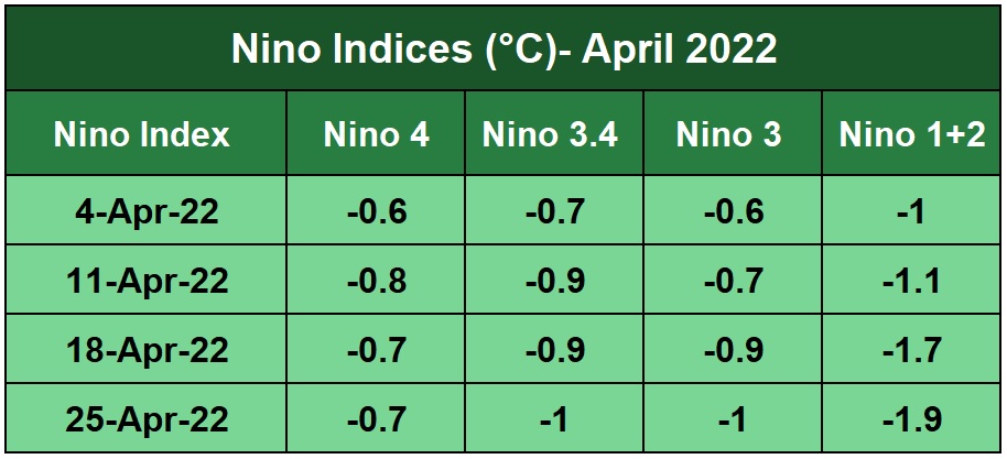
La Nina has defied its crash. Coldwater layers seem to be more stable than before and therefore delaying the expected warming of the ocean. Currently, there is a large scatter of Nino Indices across the equatorial Pacific. The discrepancy has grown over the last 2 weeks, more in the eastern half than the western one.
Oceans seem to retain their memory longer than the land. Loss of heat, more often than not, is a gradual and slow process. Accordingly, ENSO-neutral has to wait in the wings, pending cool stay being vacated, tentatively in June 2022.
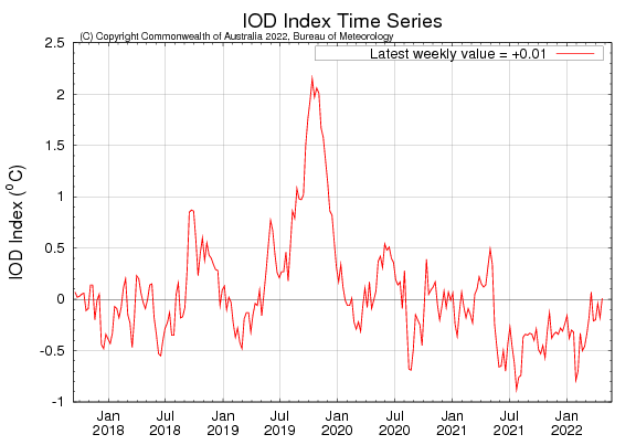
IOD: Surface waters are warmer than the average over most of the Indian Ocean. However, this trend is likely to reverse on the western half of the ocean. IOD is currently neutral. The latest IOD index value for the week ending 24th April 2022 was + 0.01°C.
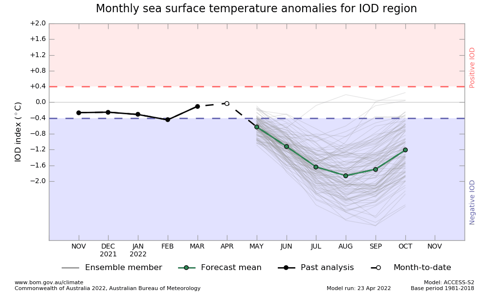
There is a model consensus with bright chances of having -ve IOD developing by May/June 2022. Caution is to observe with this prediction, as the model outlook comes with low accuracy for the monsoon months at this point in time. A reliable forecast is likely in another 3 to 4 weeks.
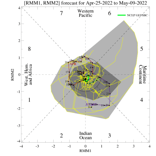
MJO: Madden Julian Oscillation is meandering along the equatorial belt, albeit coming closer over the Indian Ocean. However, the amplitude is too small to trigger any spark worth stimulating sea-born disturbance. The weak phase of MJO is expected to last for a fortnight. Accordingly, its influence will be very limited on tropical weather and climate for 2-3 weeks.
Indian Summer Monsoon Rainfall (ISMR), this season is going to witness an interesting battle between La Nina/ ENSO-Neutral, supporting good monsoon rainfall and -ve Indian Ocean Dipole, regressing weather activity. Between the two, ENSO is undoubtedly the bigger and more powerful partner, strong enough to neutralize the challenge of any spoilsport.
