
The Weather Disturbances form in the Indian Seas which subsequently become Cyclones. These disturbances can come up at any point of time, but since cyclones are mostly in Pre and Post Monsoon seasons, other times, they just manage to remain as smaller systems. The conversion rate from disturbance to a Cyclone is 80 percent in the Pre and Post Monsoon season. Which is April and May as well as October-December.
In fact, even when these systems come up in the Monsoon season, they do not convert into Cyclones. In the months of January, February and March, see very little disturbances, just about 10 percent.
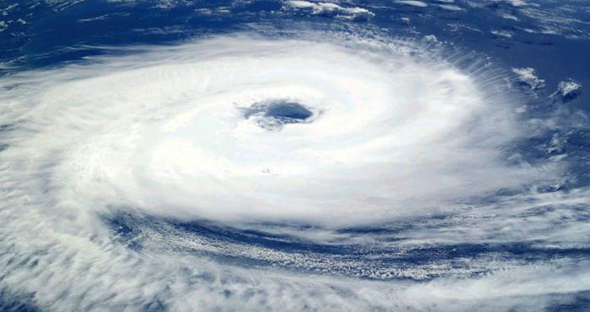
There are various stages of these disturbances starting from Depression, Deep Depression, Cyclonic Storms, Severe Cyclonic Storms and Extremely Severe Cyclonic Storms, and going up to being Super Cyclones.
If we take the years between 2010 and 2019, 2015 had 12 disturbances, out of which, the conversion rate to storm was merely four. Two were cyclonic storms and Extremely Severe Cyclonic Storm.
In the year 2018, there were 14 disturbances, out of which the number of Cyclones that formed were seven.
Meanwhile for 2019, there was a formation of 9 disturbances, out of which, seven ended up becoming Cyclones, making the year with the highest conversion rate. Out of these one was a depression and another a deep depression, one was a Cyclonic Storm, three of these were very severe Cyclonic Storms, two were Extremely Severe Cyclonic Storms and one was a Super Cyclone.
Generally, Bay of Bengal hosts more number of disturbances than Arabian Sea and that too more in Post Monsoon season as compared to Pre Monsoon. Meanwhile, Arabian Sea sees more storms in the Pre-Monsoon season and slightly less in the Post Monsoon season.
However, this year, there has been some exception with Arabian Sea seeing two storms namely Vayu and Hikaa in the Monsoon season. Meanwhile, two more storms came up in the Post Monsoon season namely Kyarr and Maha. Pre Monsoon did not see any Cyclone in the Arabian Sea.
Bay of Bengal saw Pabuk in the beginning of the year, Fani in the Pre Monsoon season, and Bulbul in the Post Monsoon season.
Record Breaking Year: The last time four Cyclones came up in Arabian Sea in a year was in 1902, and 2019 has already equaled the record and with more than a month and a half to go, there is a chance to exceed that number.
The specialty of the Arabian Sea from vis a vis Bay of Bengal
Storms that from in Bay of Bengal, retain their intensity, and strike as a Cyclonic Storm, even if they lose strength, it is very marginal. Whereas, in Arabian Sea, temperature profile is such, all coastlines including Somalia, Yemen, Oman, Iran, Pakistan, and Gujarat, have cooler temperatures, due to which, most of the storms weaken. Out of the four that formed in the Arabian Sea this year, three did not even make a landfall. It was only Hikaa which made a landfall as a Severe Cyclonic Storms. Other three storms failed to make a landfall, Vayu weakened off Gujarat Coast as a Depression, Kyarr, which was a Super Cyclone dissipated close to the coast of Somalia, Maha also weakened before it could hit the Gujarat Coast. The frequency of storms has been high this time, but majority did not hit the coast.
Bay of Bengal had three storms, Pabuk which came from Thailand in January, entering Andaman Sea did not make landfall. As it is January is not a favourable month and environmental conditions are not supportive that time, thus not much expectations were there from the storm.
Next was Fani, between April 26 and May 4, it became an extremely severe Cyclonic Storm, equivalent to Cat 4 and made landfall as the same category, weakening only after hitting the coast. The recent Bay Cyclone Bulbul was also strong enough and only weakened from a Very Severe Cyclone to a Severe Cyclone at the time of landfall. Reason for its weakening was that the storm where it was heading was the Sunderban Delta, which is a marshy area, with lots of mangroves, which mitigated the storm.
The severity of storms on either of the sides of the coastline is same, the threat potential of the Arabian Sea for the coastline reduces due to environmental conditions, whereas the damaging potential is retained in the Bay of Bengal the damaging potential is retained
Image Credit: wikipedia
Please Note: Any information picked from here must be attributed to skymetweather.com
