Updated on Nov 11, 08:54 AM: Cyclone Bulbul weakens further into Depression, continues to move in east-northeast direction
After going through several intensifications, Cyclone Bulbul has weakened further into a Depression. At 05:30 hours IST on November 11, it was over Southeast Bangladesh & adjoining South Tripura, near latitude 23.1°N and longitude 91.9°E, about 210 km north-northeast of Khepupara (Bangladesh) and 110 km south-east of Agartala. It would continue to move in east/northeast direction and is most likely to further weaken into a Low-Pressure Area during the next six hours.
Its movement would result in light to moderate rainfall in many parts of South Assam, Meghalaya, Tripura, and Mizoram during the next 24 hours.
Moreover, squally winds of 40-50 kmph gusting to 60 kmph prevailing around the system and neighbourhood, would decrease and come down to 20-30 kmph gusting to 40 kmph over Southeast Bangladesh and adjoining Tripura & Mizoram during the next six hours.
Updated on Nov 10, 05:00 PM: Cyclone Bulbul weakens into deep depression, to reach Northeast India as depression
The Cyclonic Storm Bulbul over coastal Bangladesh continues to move east-northeastwards, while loosing its strength. Cloud configuration indicates that Bulbul has already weakened into a deep depression. In fact, Bulbul would further weakened into a Depression by tonight.
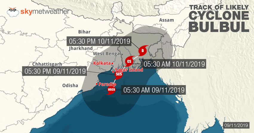
The system is centered near Latitude 22.3°N and Longitude 90.0°E, quite close to northwest of Khepupara, Bangladesh, around 210 km east-northeast of Sagar Islands, West Bengal, 120 km east-northeast of Sunderban National Park and 170 km east-southeast of Kolkata. It has been a slow moving system, Bulbul would now be heading towards northeastern states.
Rains have reduced significantly over West Bengal but light to moderate rainfall are likely to continue over North & South 24 Parganas, East Medinipur and Nadiya districts. Light to moderate rains are also likely at many places of South Assam, Meghalaya, Tripura, and Mizoram during next 24 hours.
Updated on Nov 10, 05:00 PM: Cyclone Bulbul claims 7 lives in West Bengal
Cyclonic storm Bulbul has wreaked havoc over coastal parts of West Bengal and has resulted in the death of seven people in various parts of the state, reports stated.
The storm, which hit the state as a Severe cyclone, brought very heavy rains as well asGale force windsuntil the wee hours of Sunday. It also caused uprooting of trees and cables being snapped in many parts.
Moreover, the Cyclone claimed five lives in North 24 Parganas itself. One person was killed in Kolkata and another lost their life in Kolkata.
The storm threat over West Bengal is over now and the state will only see light to moderate showers now, that too, only in a few parts.
Updated on Nov 10, 09:30 AM: Cyclone Bulbul to weaken into Depression soon, to move towards Northeast India
Cyclone Bulbul made landfall over the Indo-Bangladesh coast last night and caused heavy to very heavy rains over both these areas.
In fact, in the last 24 hours until 8:30 am today, Parts of Bangladesh saw heavy rains including Khepupara 105 mm rains, Bhola 99 mm, Barisal 139.5 mm, Jessore 52 mm. Meanwhile, Contai in West Bengal saw a whopping 166 mm of rains, Dum Dum Airport in Kolkata 103 mm, Alipore in Kolkata 91.7 mm, Digha 96.6 mm, Diamond Harbour 91 mm.
Cyclone Bulbul at 5:30 am in the morning was over Bangladesh and adjoining Coastal West Bengal centred at 22.2 °N and Long 89.5°E about 125 km ESE of Kolkata. 80 km WNW of Khepupara.
The system will keep moving northeastwards towards Northeast India as it crosses Bangladesh and weaken into a Deep Depression in the next few hours and further into a Depression thereafter. Rains are expected to be seen in Northeast India now.
Updated on November 9, 2019, 10:30 PM :Cyclone Bulbul makes landfall over West Bengal, red alert to remain for next 6 hours
Cyclone Bulbul finally made landfall over Indo-Bangladesh coast on Saturday night as severe cyclonic storm. Bulbul had crossed the coast abeam Sagar Islands and continues to track northeastwards. According to weathermen, the landfall process that takes about two hours to complete and has nearly completed.
The storm is accompanied with torrential rains and high velocity winds to the tune of 110-120 kmph gusting up to 130 kmph. lightning strikes are to be watched out for, which may be damaging. Coastal areas of West Bengal inclusive of Digha, Howrah, Hooghly, 24 Parganas, Medinipur are witnessing winds in excess of 100 kmph while Kolkata winds were in excess of 70-80 kmph.
As reiterated, the next 6 to 8 hours continues to be crucial for West Bengal as Bulbul would take another six hours to weaken into Cyclonic Storm after crossing coast. Thus, next 12 hours will be crucial. Storm surge will be from 8 to 10 feet that would lead to inundation in the low lying areas.
Moving northeastwards further, it would head for the northeastern states of India as a depression. However, this would be not before Sunday morning.
Bulbul has already given extremely heavy rains in span of 12 hours, wherein Kolkata recorded 72 mm of rains, Digha 93 mm, and Diamond Harbour 75 mm. Heavy rains would continue to lash several parts of West Bengal throughout.
Updated on November 9, 2019, 8:30 PM:Cyclone Bulbul to make landfall anytime now
Bulbul has now weakened into aSevere Cycloneas it gets very close to the coast. In fact, peripherals of the storm are already touching Sagar Islands and the landfall will begin very soon. It will take about two hours for the eye to cross the land, from the time the eye touches land.
Gale force winds, very heavy rains and storm surge of about 8 to 10 feet will be seen as the storm makes landfall. Residents are advised to exercise caution and stay safe.
Updated on November 9, 2019, 3:30 PM:Cyclone Bulbul gets closer to coast, landfall tonight
Very Severe Cyclonic Storm Bulbul is currently near Latitude 20.9°N and Longitude 87.9°E, 90 km south-southeast of Digha. The storm is expected to weaken a little and become a Severe Cyclone at the time of landfall. It will make landfall over the coasts of West Bengal and Bangladesh between Sagar Islands and Khepupara tonight.
Heavy rains have already occurred in many parts of Odisha yesterday and today, West Bengal has been seeing heavy showers with Dum Dum Airport in Kolkata recording 45 mm of rains in six hours' time. More showers are coming up.
Updated on November 9, 2019, 9:45 AM:Cyclone Bulbul to make landfall today, alert issued for coastal areas
As of 0830 hrs IST of today morning, the Very Severe Cyclonic Storm ‘Bulbul’ lies centered over Northwest and adjoining West-central Bay of Bengal, near Lat.20.4°N and Long. 88.0°E about 285 km south of Kolkata, 110 km east-southeast of Paradip (Odisha), 190 km southsouthwest of Sagar Islands (West Bengal) and 340 km South-southwest of Khepupara.
The system is likely to move northeastwards while weakening gradually, and cross West Bengal – Bangladesh Coast between Sagar Islands and Khepupara (Bangladesh), across Sunderban delta by late evening or night today i.e. November 9 as a Severe Cyclonic Storm. Winds to the tune of 110-120 kmph gusting to 135 kmph are likely to blow over the region.
Updated on November 8, 2019, 2:00 PM: Schools closed in many districts of Odisha on Nov 9 as Bulbul gets closer
As Severe Cyclone Bulbul gets nearer, authorities have started to prepare with the Special Relief Commissioner declaring closure of schools in many districts of Odisha including Balasore, Bhadrak, Cuttack, Kendrapara, Jagatsinghpur, Puri, Khurda, Mayurbhanj and Jajpur on November 9.
Along with this, deployment of ODRAF and NDRF teams has already taken place in these nine districts of the state with the fire services personnel kept on standby.
Government employees in these nine districts have been ordered by the Chief Secretary to not leave headquarters.
Both the Cyclone and flood relief centres along with communication systems are ready for the incoming storm. Also, authorities are ensuring that these shelters are in proper condition. Earlier only, Puri, Jagatsinghpur and Kendrapada had declared holiday on Nov 8 and 9, for colleges, school as well as Anganwadi centres as a precautionary measure.
Updated on November 8, 2019, at 10:10 AM: ‘Severe’ Cyclone Bulbul becomes ‘Very Severe’ Cyclone, to move towards coast now
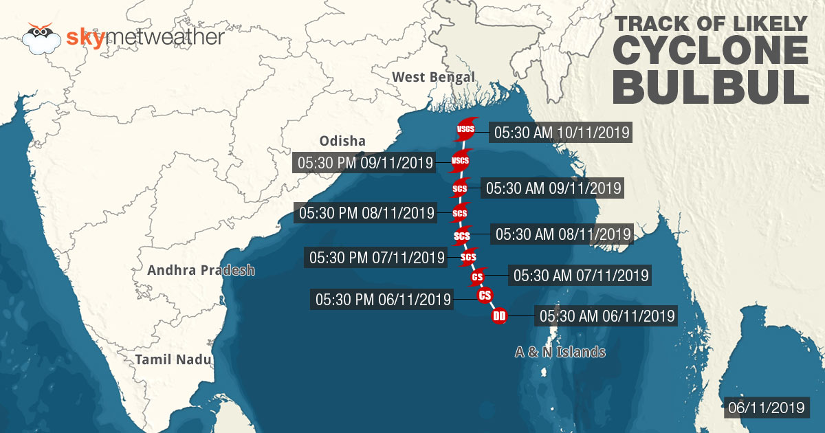
Cyclone 'Bulbul' over west-central & adjoining east-central Bay of Bengal continues to move towards north-northwestward direction with a speed of 10 kmph during the past six hours. As of 05:30 hours IST of today, the 08th November, 2019, the system has intensified into a ‘Very Severe’ Cyclonic Storm and lies centered over west-central & adjoining east-central Bay of Bengal, near Latitude 16.9°N and Longitude 87.6°E, about 390 km south-southeast of Paradip, 530 km south-southwest of Sagar Islands and 630 km south-southwest of Khepupara.
The system is now likely to intensify further while moving northwards till the morning of November 9. Thereafter, it is very likely to re-curve northeastwards and cross West Bengal and Bangladesh Coast as a Severe Cyclonic Storm. This is when very strong winds to the tune of 110-120 kmph gusting to 135 kmph are expected to blow over the region.
Updated on November 8, 2019 at 08:14 AM: Cyclone Bulbul in the Bay of Bengal underwent an intensification last evening at 5.30 pm, becoming a Severe Cyclonic Storm. The Storm is expected to undergo more such intensification and even become a Very Severe Cyclonic Storm in the next 24 hours. The storm is currently near Latitude 16.4°N & Long. 87.8°E, lying about 580 km south of Sagar Islands.

Updated on November 7, 2019 at 4:10 PM: Cyclone Bulbul to become Severe Cyclonic Storm anytime now, very severe cyclone in next 24 hours
Cyclone Bulbulis all set to intensify further and become a severe cyclonic storm over east-central Bay of Bengal anytime now. According to Skymet Weather, Bulbul is travelling in deep open waters in conducive environment of low vertical wind shear and warm sea surface temperatures. In fact, with longer sea travel ahead, Bulbul is very likely to become more powergul and strengthen into very severe cyclonic storm by late hours of November 8.
The system is presently centered near 15°N and Longitude 90°E, about 640 km south-southeast of Paradip, Odisha, 740 km south-southeast of Sagar Islands, West Bengal and 780 km south-southwest of Khepupara, Bangladesh.
According to weather models, Cyclone Bulbulwould continue to move in north-northwest direction in the sea for the next three days, before re-curving. It is expected to make landfall around November 10 between Chandbali and Sagar Island, but there are still disagreement among the weather models over the same.

With Cyclone Bulbul inching closer and intensifying, rains as well as surface winds would too increase by November 8. Moderate to heavy rains would lash North Coastal Odisha and West Bengal, with strong surface winds of 70-80 kmph gusting up to 90 kmph.
Rains would be at peak by November 9 and 10. By this time, Bulbul would have reached quite closer to the Indian coast as well as re-curving. Thus, heavy to very heavy rains would lash North coastal Odisha and West Bengal which would be accompanied with damage potential winds of 80-90 kmph gusting up to 100 kmph.
Updated on November 7, 2019 at 8:10 AM: Deep Depression intensifies into Cyclone Bulbul
The Deep Depression in the Bay of Bengal has intensified into Cyclonic Storm, Bulbul. The storm is situated about 770 km South southeast of Paradip in Odisha. It is likely to follow a north-northwestward track, moving towards the state of West Bengal and Bangladesh. There is a high probability of the system becoming a Severe Cyclonic Storm in the next 12 hours.
Updated on November 6, 2019 1 PM: Cyclone Bulbul to arrive today, to trigger heavy rain, damaging winds in Odisha and West Bengal
The likelycyclonic storm Bulbulbrewing in Bay of Bengal is likely to form by Wednesday evening or early night. The depression had intensified into a deep depression on early Wednesday morning and is presently seen over east-central and adjoining southeast Bay of Bengal. It is likely to strengthen further into a cyclonic storm by Wednesday evening or early nights.
The system is centered near Latitude 13.4°N and Longitude 89.3°E, about 390 km west-northwest of Maya Bandar, 810 km south-southeast of Paradip, 920 km south-southeast of Sagar Islands and 960 km south-southwest of Khepupara, Bangladesh.
Weather models are indicating towards the northwards movement, skirting the East Coast near Odisha and West Bengal. The likely storm Bulbul is most likely to make landfall somewhere between Chandbali, Odisha and Sagar Island, West Bengal, in close proximity to Bangladesh coast around November 10.
While we can expect light rains along coastal parts of Andhra Pradesh and South Odisha today, but by November 7, winds and rains both would pick up. November 8, moderate to heavy rains with squally winds of 70-80 kmph gusting up to 90 kmph would lash parts coastal parts of North Odisha and West Bengal.
Rain would peak on November 9 and 10, wherein heavy to very heavy rains would batter coastal parts of Odisha and West Bengal on November 9. Being a slow moving system, rains would also persist on November 10 as well. Also, wind speed would also increase significantly and would be of damage potential to the tune of 80-90 kmph gusting up to 100 kmph.
Chandbali, Puri, Gopalpur, Balasore, Diamond Harbour, Digha and Canning would have the maximum bearing including some extremely heavy rains. In fact, areas little away from the coast like Baripada, Midnapore, Kolkata, Bhubaneswar might also see heavy rains.
Updated on November 5, 2019 5 PM: Cyclone Bulbul to form in 24 hrs, Odisha and West Bengal on heavy rain alert
As predicted, likelyCyclone Bulbulis all set to make an appearance in Bay of Bengal in the next 24 hours. At present, the weather system is seen as a depression over East-central and adjoining Southeast Bay of Bengal and North Andaman Sea.
It is centered near Latitude 13.1°N and Longitude 91°E, about 200 km west-northwest of Maya Bandar, Andaman Islands, 920 km southsoutheast of Paradip, Odisha, 1000 km south-southeast of Sagar Islands, West Bengal and 990 km south-southwest of Khepupara, Bangladesh.

According to Skymet Weather, the system has been intensifying rapidly, much faster than expected. The system has covered journey from low pressure area to depression in mere 18-24 hours. In fact, present cloud configuration and atmospheric conditions are already indicating that system has intensified into a deep depression. Looking at this, we expect deep depression to induce a cyclonic storm in Bay of Bengal during the next 24 hours.
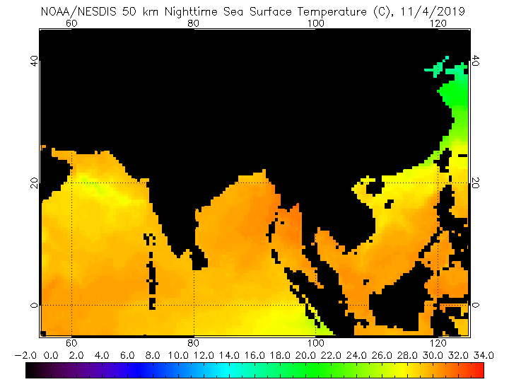
As per weathermen, reason behind the rapid intensification can be attributed to extremely favourable weather conditions. The likely Cyclone Bulbul is travelling in deep ocean waters, encountering with low vertical wind shear, warm sea surface temperatures to the tune of 31°C-32°C and moist winds in abundance.
It is very likely to move west-northwestwards for the next 24 hours and northwestwards in subsequent 24 hours. Thereafter, as the system inches closer to the coast, it would start moving in northward direction along the coast. The system is expected to cross the coast somewhere between Chandbali in Odisha and Sagar Island, West Bengal.
Features of Potential Cyclone Bulbul is somewhat akin to Cyclone Titli that had developed in Bay of Bengal during October 2018. Like Titli, Bulbul has the same place of origin and is also taking similar route through the ocean. In fact, indications are there that Bulbul can also become very severe cyclone same as Titli did.
Odisha and West Bengal on heavy rainfall alert
At present, the potential cyclonic storm is too far from the coast to have any impact over the land mass. However, by tomorrow, weather activities would start picking up and we can expect light rains over CoastalAndhra Pradeshand Odisha on November 6-7.
We would see significant increase in the rainfall on November 8-9, but with system, rain belt would have also shifted. We can expect moderate to heavy rains over North Coastal Odisha and Gangetic West Bengal. These showers would be accompanied with strong surface winds of 50 kmph to 60 kmph gusting up to 70 kmph.
By November 10, potential cyclone Bulbul would most likely make landfall, triggering heavy to very heavy rains, with squally winds to the tune of 80 kmph to 90 kmph gusting up to 110 kmph. Places like Chandbali, Puri, Gopalpur, Balasore, Diamond Harbour, Digha and Canning would be on alert for some extremely heavy rains. In fact, areas like Baripada, Midnapore, Kolkata, Bhubaneswar might also see heavy rains.
However, sea conditions would remain rough to very rough all along the East Coast. Fishermen along Tamil Nadu coast are advised not to venture deep inside the water, while complete suspension of fishermen activities are advised along and off Andhra Pradesh, Odisha and West Bengal coast.
Image Credit: NDTV
Any information taken from here should be credited to skymetweather.com