
Updated on Sep 26, 2021, 4:00 PM: Cyclone Gulab to make landfall tonight
Cyclone Gulab may gain speed gradually and keep heading towards North Coastal Andhra Pradesh. It is likely to make landfall, sometime between 8 and 11 PM IST. The cyclone is expected to make landfall between Kalingapatnam and Srikakulam.
The track of the system is as per the numerical weather guidance. There is no consensus between models about the after landfall track. Some of the models are suggesting that after landfall, the system may travel through Central India and re-emerge in the Arabian Sea becoming a storm once again. Meanwhile, other models suggest that the system will possibly weaken rapidly. The weakening may occur due to the unfavourable terrain that it will encounter while it travels on land.
Published on Sep 25, 2021: Cyclone Gulab forms in Bay of Bengal, hefty rains in Andhra Pradesh and Odisha
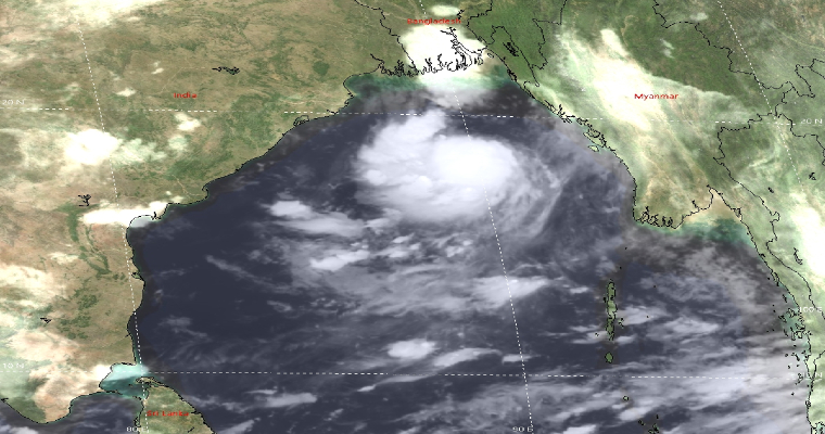
The low pressure area which had formed in the Bay of Bengal has seen some rapid intensification overnight, now intensifying into Cyclone Gulab. The Cyclonic Storm is almost about 500 km east southeast of Gopalpur in Andhra
The storm will be tracking west north-westward. The storm will be crossing the coast just on the border of Andhra Pradesh and Odisha, possibly close to Srikakulam. The landfall of this storm is expected to take place by tomorrow evening hours.
So far, two storms have formed in the season, first one being Cyclone Tauktae which had formed in the Arabian Sea, between May 14 and 19, making a landfall at Diu. The other one was Cyclone Yaas that formed in the Bay of Bengal, around May 23 and 28, which had crossed the Odisha coast.
The storm is a fast-moving weather system and will hold as a Cyclonic Storm itself and since sea travel will be less therefore, it may not intensify into a severe cyclone. While crossing the coast, the system may weaken.
While the cyclone season begins in October, we are at the fag end of September and since the sea surface temperatures usually become favourable now, it is not rare for us to see Cyclones at this stage.
Sea conditions will be rough to very rough over Odisha and North Andhra Pradesh coast. The wind speed of the cyclone will be at around 80 kmph gusting up to 100 kmph, i.e. 40-50 knots at the time of crossing and will rapidly weaken. Wave height may be 14-16 feet.
Moerover, moderate to heavy rain with isolated very heavy spells may occur over South Odisha and North Andhra Pradesh post during next 24 to 48 hours. Most affected districts of Odisha maybe Kendrapara, Jagatsingpur, Cuttack, Bhubaneswar, Khordha, Puri, Ganjam, Gajapati, Kandhmal and Rayagada. In Andhra Pradesh, Srikakulam, Vijayanagaram, Visakhapatnam, East Godavari, West Godavari, Guntur and Krishna may receive heavy downpour with strong winds.
Fishermen are advised not to venture into deep sea areas of Westcentral adjoining north Bay of Bengal during 25th to 26th September, also along and off Odisha coast, West Central Bay of Bengal adjoining northwest Bay of Bengal during 25th to 27th September, 2021.
Moreover, another system is waiting in the wings and has already caused damage in Vietnam named Tropical Storm Dianmu. The system will enter into the Bay of Bengal shortly, as a weakened one.
