
Updated on September 20, 2018 9:30 pm: Monsoon 2018 : Cyclone Daye forms in Bay, torrential rains in Odisha, Andhra Pradesh
Deep depression in west-central Bay of Bengal has finally intensified into a Cyclone Daye. It is now marked over west-central and adjoining north-central Bay of Bengal.
The cyclone is presently centered at latitude 18.1°N and longitude 86.3°E, around 100 km southeast of Gopalpur, Odisha, around 160 km east of Kalingapatnam, Andhra Pradesh and 450 south-southwest of Kolkata, West Bengal.
The system is moving at good pace of around 24 kmph in west-northwest direction. Cyclone Daye is likely to cross the Odisha coast near Gopalpur around midnight.
Click here to read the full article
Updated on September 20, 2018 1 pm: Monsoon 2018 : deep depression in Bay, cyclone in making
As predicted, the depression over west-central Bay of Bengal as intensified into a deep depression over the same region. The system is now centered at latitude 17.5°N and longitude 87°E, around 300 km east-southeast of Kalingapatnam, Andhra Pradesh and about 295 km east-southeast of Gopalpur, Odisha.
Weathermen are of the view that conditions are very favourable for the system to further conecentrate into a cyclonic storm in span of another 12 hours. According to Skymet Weather, sea surface temperatures are warm and vertical wind shear is also low. Both the factors will lead to intensification of this system into a tropical storm.
The only deterring factor for the system would be approaching land mass. However, chances seem to be bright to the system to transform into a cyclone. If this happens, it would be named as ‘Daye’.
The system would continue to move in west-northwest direction and is most likely to cross the Indian coast as a cyclonic storm. The system would made landfall somewhere between Kalingapatnam and Puri by midnight. This system would also be accompanied with strong winds of 60-70 kmph gusting to 90 kmph.
Updated on September 20, 2018 8 am: Monsoon 2018-Depression forms in Bay, deep depression next
The well-marked low pressure area over east central Bay of Bengal has finally intensified into a depression. It is now prevailing over west-central Bay of Bengal and continues to move in west-northwest direction. The system is presently centered at latitude 17.4°N and 88.8°E, which is around 320 km south east of Gopalpur, Odisha.
Travelling in conducive environment and with this, we expect depression to further get more organised and induce a deep depression in the next 12 hours.
The system would move in the same direction and cross the Indian coast somewhere between South Odisha and North Andhra Pradesh coasts. To be precise between Kalingapatnam and Puri by tonight.
The system would be accompanied with strong winds with the speed of 55-65 kmph gusting to 75 kmph.
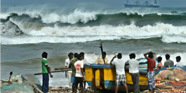
With this system moving closer to the east coast, we expect some heavy to very heavy rain and thundershowers along with lightning strikes over Odisha, North Andhra Pradesh, Gangetic West Bengal, Jharkhand and Chhattisgarh during the next 24 hours.
Sea conditions will become rough to very rough off and along the East Coast. Local and fishermen are advised not to venture out in the deep water.
Peripherals of the system would also give some rain activity over Coastal Tamil Nadu. Not only this, rains would also revive along the West Coast. In the subsequent 24 hours, the system would also start giving rains over the central parts like Madhya Pradesh. Bihar and Jharkhand would also see some good spells.
Image Credit:en.wikipedia.org
Any information taken from here should be credited to skymetweather.com
