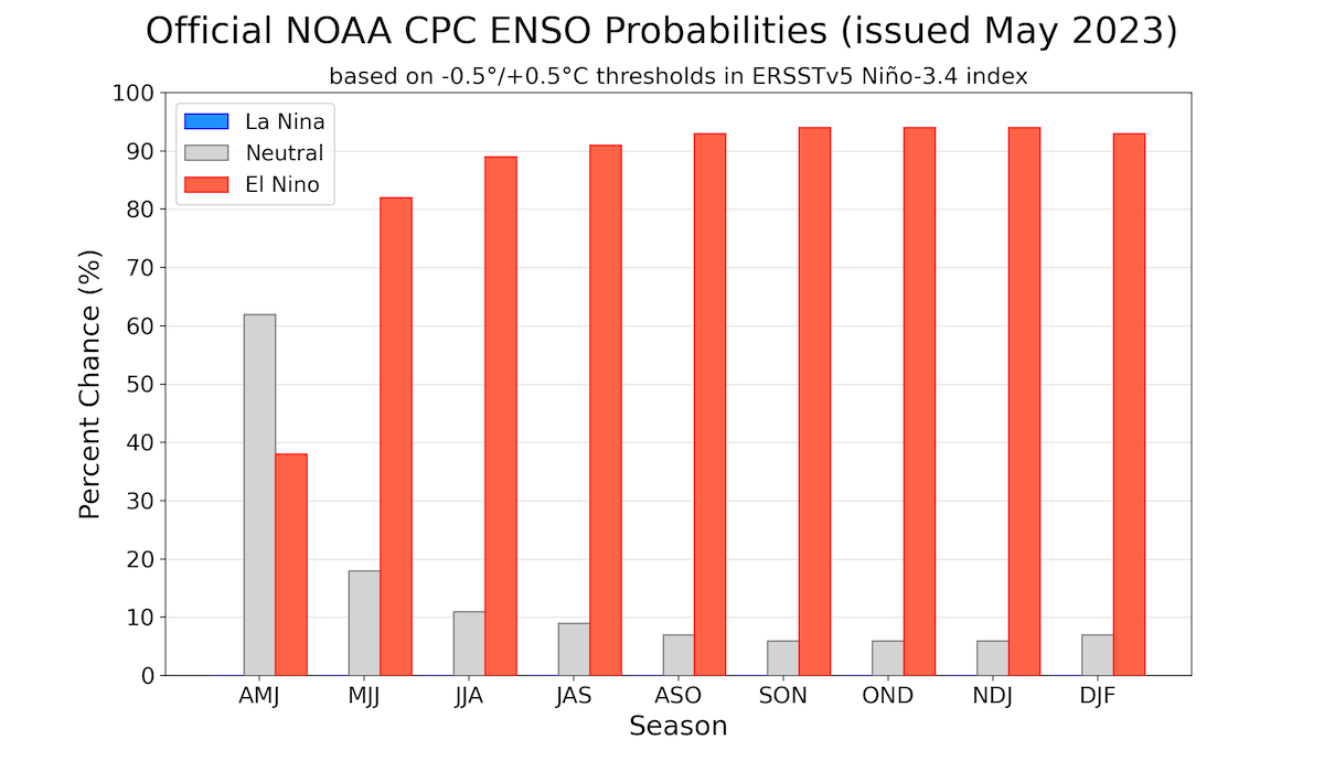
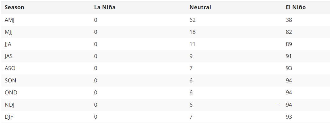
A transition from Enso- neutral is expected in the next few weeks. The share of El Nino is likely to increase to nearly 80% at the beginning of the season and reach in excess of 95% towards fall of the year. La Nina is completely wiped off and the neutral margin get diluted to single digit, as the season progress.
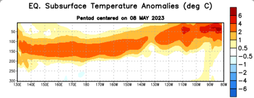
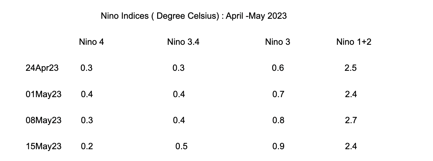
ENSO : Positive sub-surface temperature anomalies have expanded eastward and now dominate the equatorial Pacific Ocean. Sub-surface warming can help accelerate the development of El Nino. El Nino is an ocean - atmosphere coupled phenomenon. Tropical Pacific Ocean looks ready for quick transition to El Nino but the atmospheric response appear to be sluggish. Latest Nino 3.4 measurement has reached the threshold mark of 0.5 degree.
This is a necessary but not sufficient condition for declaring El Nino. Nino 3.4 SST's need to stay >/= 0.5 Degree Celsius for the next several seasons. Average Southern Oscillation Index (SOI) for the last 30 days had reached marginally negative. Sustained negative values below -5 support build up of El Nino. Therefore ENSO-neutral conditions are expected to prevail a little longer than assessed earlier. Accordingly, El Nino 'WATCH' continues.
A reduction of the east -to-west surface trade winds are the key component of Walker's circulation. This feature continue to hold marginally below the average strength. Sufficient weakening of Walker's circulation is still awaited to facilitate firm El Nino conditions.
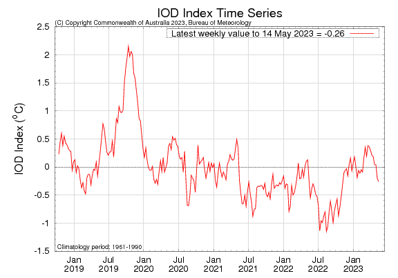
IOD : The Indian Ocean Dipole is currently neutral. The IOD index value for the week ending 14 May 2023 was -0.26 degree, which is within neutral bounds( -0.40 and +0.40 degree). After staying positive neutral for nearly 10 weeks, the index has slipped to negative neutral for successive 2 weeks. Most models predict a positive IOD event to develop in the coming months. Though, model accuracy is generally low at this time of the year. Positive IOD increases precipitation to above average in East Africa and India while it decreases precipitation in Indonesia and Australia. Even with the latest simulation techniques, IOD's are difficult to predict several months in advance. For Indian monsoon, IOD prediction is needed from summer to autumn (Northern Hemisphere). However, it faces 'Winter Prediction Barrier' like the El Nino has 'Spring Barrier'.
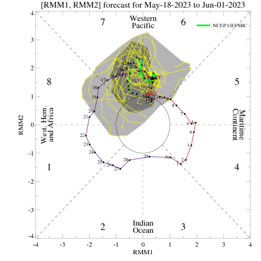
MJO: Madden Jullian Oscillation is sailing across phase 6&7 over the Western Pacific. The amplitude is marginally decreasing during the last week, but still adequate to trigger convection. The MJO remained active while propagating eastward from the Maritime Continent in to Western Pacific. MJO will be supportive for deep low pressure area over the Philippines Sea and neighbourhood. Western Pacific seems to be turning favourable for tropical cyclone development during last week of May 2023. West Pacific typhoons at this time do not augur well for setting in of southwest monsoon, as it results depletion of moisture over the Indian Sub-Continent.
Global average temperatures tend to be higher in El Nino years than in La Nina or ENSO-neutral years. Warm ocean conditions are not just limited to the tropical Pacific, most other oceans globally are in the grip of rising spree. Glimpse of cool are rather few and getting outperformed by global simmering.