

The beginning of journey towards Southwest Monsoon 2020 is not very far away and very soon the countdown to the four-month long season would begin. Predicting Monsoon forecast has always been a tricky thing for the forecasters worldwide.
Monsoon rains continue to be of surprising nature, with the season taking any turn during its course. The most recent example could be of Southwest Monsoon 2019, which was initially predicted well below normal but finished with excess rains not just for the year but in last 25 years.
With just five months to go, we would in the most awaited season. India, primarily an agri-driven country, depends heavily on the season, whose performance has a large say in the economy. Thus, it even becomes more precarious situation for meteorologists to forecast the season performance.
While forecasting the Monsoon season, there are several oceanic parameters taken into account. Out of these, the most important is El Niño that is invariably related with below-normal rainfall during the Monsoon season that spans from June to September. In fact, the mere presence of this deadly oceanic parameter holds the power to corrupt the entire Monsoon season.
Looking at the present situation, Equatorial Sea Surface Temperatures (SST) are near to above average across the Pacific Ocean in the increasing order from East Pacific coast to westward to central Pacific. There is a probability of around 60 per cent that ENSO to remain neutral through Northern Hemisphere Spring 2020 and 50 per cent chance through Summer season.
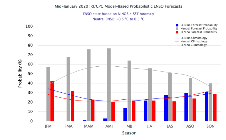
As per weathermen, present indices are the true representation of the sea state. Currently, sun is in its extreme southernmost position. Thus, the heat potential derived from the sun proximity is not there. By March, as the sun comes over Equator, oceans tend to warm up in the equatorial region. This is what leads to spring barrier for Niño indices, where in we see increase in the indices, but they are not considered trustworthy as they change with movement of sun.
Now, if present situation is to be believed, this is a great relief for the country, with El Niño not being around. In 2019, the presence of declining El Niño at the time of onset of Monsoon had not only delayed its arrival but also had impacted the rainfall performance. June had ended with 33% of deficit Monsoon rains which was almost equivalent to drought like situation.
IOD (INDIAN OCEAN DIPOLE)
Apart from El Niño, there are other two prime oceanic parameters that unlike the above-mentioned phenomenon are linked with good Monsoon rains. The first one would be IOD (Indian Ocean Dipole) which when being positive aides the rainfall during the season.
It had been a game changer last year, which revived the destiny of Southwest Monsoon 2019. We had witnessed the longest as well as strongest spell of IOD, which persisted for a prolonged period of six months i.e. from April to December. All through this while, IOD values were above the threshold value of 0.4 degree Celsius and in between also peaking to the maximum of 2.2 degree Celsius that is highest since 1997.
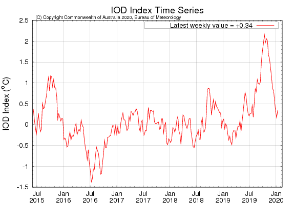
After excess Monsoon rains and triggering formation of record nine cyclone in Indian history, IOD has finally become neutral. As on January 19, the current IOD value is 0.1 degree Celsius.
Statistically, IOD has a ratio of 1:1:4 which is positive, negative and neutral, respectively. Since 1960, there have been 13 incidents of positive IOD, 12 incidents of negative IOD and 35 episodes of neutral IOD. IOD events are typically unable to form during the southern summer and autumn because Monsoon trough (ITCZ- Inter Tropical Convergence Zone) shifts south over the tropical Indian Ocean.
According to meteorologists, occurrence of consecutive episodes of positive IOD as well as negative IOD are not very common. However, there has been exceptions like years 1982 and 1983 saw positive IOD. But presence of El Niño had made the difference. El Niño has the power to negate the impact of IOD.
1982 was strong El Niño year that resulted in drought to the tune of 85%. Meanwhile, in 1983 which was ENSO neutral year, IOD was able to drive Monsoon saw that ended with excess rains by 113%.
Thus, who knows that in times of these extreme weather events, we might see formation of a positive as well as strong IOD like in 2019. For that we need to wait and watch, as the picture would be clear around April when the ITCZ would start moving north again.
MJO (MADDEN-JULIAN OSCILLATION)
MJO is eastward moving ‘pulse’ of cloud and rainfall near to the equator that typically occurs every 30-60 days for a particular region. Whenever in phase 2 or 3, which is Indian Ocean, it results in enhanced rainfall over the Indian region and if coupled with positive IOD, it can do wonders.
According to weathermen, it influences the global Monsoon patterns including Indian Monsoon. It results in formation of cyclones during strong MJO events for Indian season. Again, as it is transitory feature, we need to wait and watch for its position as we get closer to the upcoming Monsoon 2020.
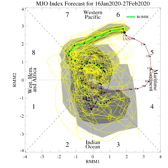
Image Credit: NDTV
Any information taken from here should be credited to skymetweather.com
