Monsoon 2019 has been on a roller coaster ride, this season. From almost drought like condition during the onset month of June to flooding situation in August. Well, this extreme transformation in the weather conditions can be attributed to an oceanic parameter ofIOD (Indian Ocean Dipole) as well as MJO (Madden-Julian Oscillation).
As reiterated, positiveIODand presence of MJO in Indian Ocean are linked with good Monsoon rains. Together, they even have the power to negate the effects ofEl Niñoup to great extent. This is what has happened with Monsoon 2019.
WithEl Niñobeing in the vulnerable stage of declining and both IOD and MJO being strong and favourable phase, Monsoon rains took a vigorous turn July end onward.
As expected,El Niñohad started showing a declining trend in July itself, with continuous fluctuations in the equatorial sea surface temperatures (SST). Although after decrease inEl Ninovalues, SST had risen again but soon declining thereafter. And, for the third consecutive week, SSTs continue to decline. In fact, current week saw a significant drop wherein SSTs went down from 0.4°C to 0.1°C.
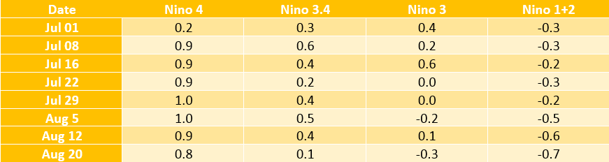
According to weathermen, these fluctuations are a clear indication of thecollapse of El Niño. The deadly phenomenon is now inching closer towards neutral. For declaring neutral conditions, the Oceanic Niño Index (ONI), which is three months running mean of SST anomaly in the Niño 3.4 region, must settle below the threshold value of 0.5°C.
So far, ONI values have been settling above the normal average for the last nine consecutive spells, but with decreasing trend for the last two episodes. There is a high possibility of the next episode of JJA (June-July-August) to settle below the required temperature of 0.5°C.

As per meteorologists, El Niño typically lasts for 9-12 months and we have already seen nine episodes of the same so far. It tends to develop from March to June and peaks from December to April on account of increase in warming in Pacific Ocean due to proximity of sun to the equator. At present, El Niño is not in the favourable time zone and is now heading towards collapse.
There is a mere 30% probability of El Niño at present, which would further go down as we proceed.
On the other side, IOD has been very much positive and has been strengthening during the last few months. In fact, MJO has also visited Indian Ocean twice and that too with high amplitude. As a result, we saw Monsoon rains picking up pace from July end onward. As on August 23, the countrywide cumulative Monsoon rainfall for the season is surplus to the tune of 1%.
Now, the time has finally come to bid adieu to El Niño, gradually paving way for ENSO neutral conditions. According to Skymet Weather, El Niño would now have the least impact on the Monsoon rainfall. August has already exceeded the expectations and is largely surplus. In fact, the surplus rain figure had once reached to 49%, while at present i.e on August 22, August rains are excess by 26%.
IOD is here to stay across the Monsoon season, with chances of MJO visiting Indian Ocean again by the fag end of September. Along with this, Southwest Monsoon works on its own dynamics that even perform in the absence of oceanic parameters.
Weather models had earlier indicated towards decline of El Niño during the second half of Monsoon. Accordingly, Skymet Weather had also predicted more rains in August and September as compared to June and July.
Image Credit: NDTV
Any information taken from here should be credited to skymetweather.com


